Phase MOSAIC is a surface and image processing and analysis program. It was built as a tool to register multiple sets of data from phase-shifting interferometers. The "MOSAIC" in Phase MOSAIC stands for Multiple Overlapping Sub-Aperture Interferometric Calculation. Phase MOSAIC has evolved into a general purpose tool for surface and image analysis.
Phase MOSAIC analyzes surface and image data. Fundamentally, each contains numbers arranged in a raster format. Additionally, Phase MOSAIC includes other data elements. Here are the elements of surfaces and images:
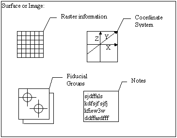
The coordinate system is used to map the raster information to "real world" global coordinates. This can be set up to interpret the raster information with a specified rotation, translations, and scaling.
Fiducial groups are a collection of locations specified in the raster information. Phase MOSAIC supports sub-pixel fiducial locations that can be used for fitting coordinate systems or placing mask elements, etc.
Note text can be included with data to document a series of operations, summarize calculation results, or any other distinguishing information that may be helpful to include with the data.
Images are represented by a single array of raster information. Ordinary image file formats usually only support raster data. Each raster pixel value represents color. Phase MOSAIC supports an additional image file format which includes the other elements. Phase MOSAIC can display common graphics file formats, as well as adding and editing the other elements.
In order to automatically process large amounts of surface and image data, Phase MOSAIC manages lists. Surface and image lists are sequences of entities that is represented by a single ASCII file containing a series of file names on each line. New surfaces or images can be produced using list entries. See Using Lists.